Malta Cart Ruts: Where to See Them and What We Know
Malta's cart ruts are parallel grooves cut into limestone bedrock. Here is where to see them, including Misraħ Għar il-Kbir, and what the theories say.
On this page
Malta's cart ruts are pairs of parallel channels cut into bare limestone, and the best-known concentration is at Misraħ Għar il-Kbir near Rabat and Buskett. Roughly 150 sets of tracks are estimated across the islands, with a distance between tracks of about 140 centimetres and depths from a few centimetres to as much as 60. This guide covers what the ruts are, where to see them, how the ground lies underfoot, and how the dating debate stands.
What Malta's cart ruts are
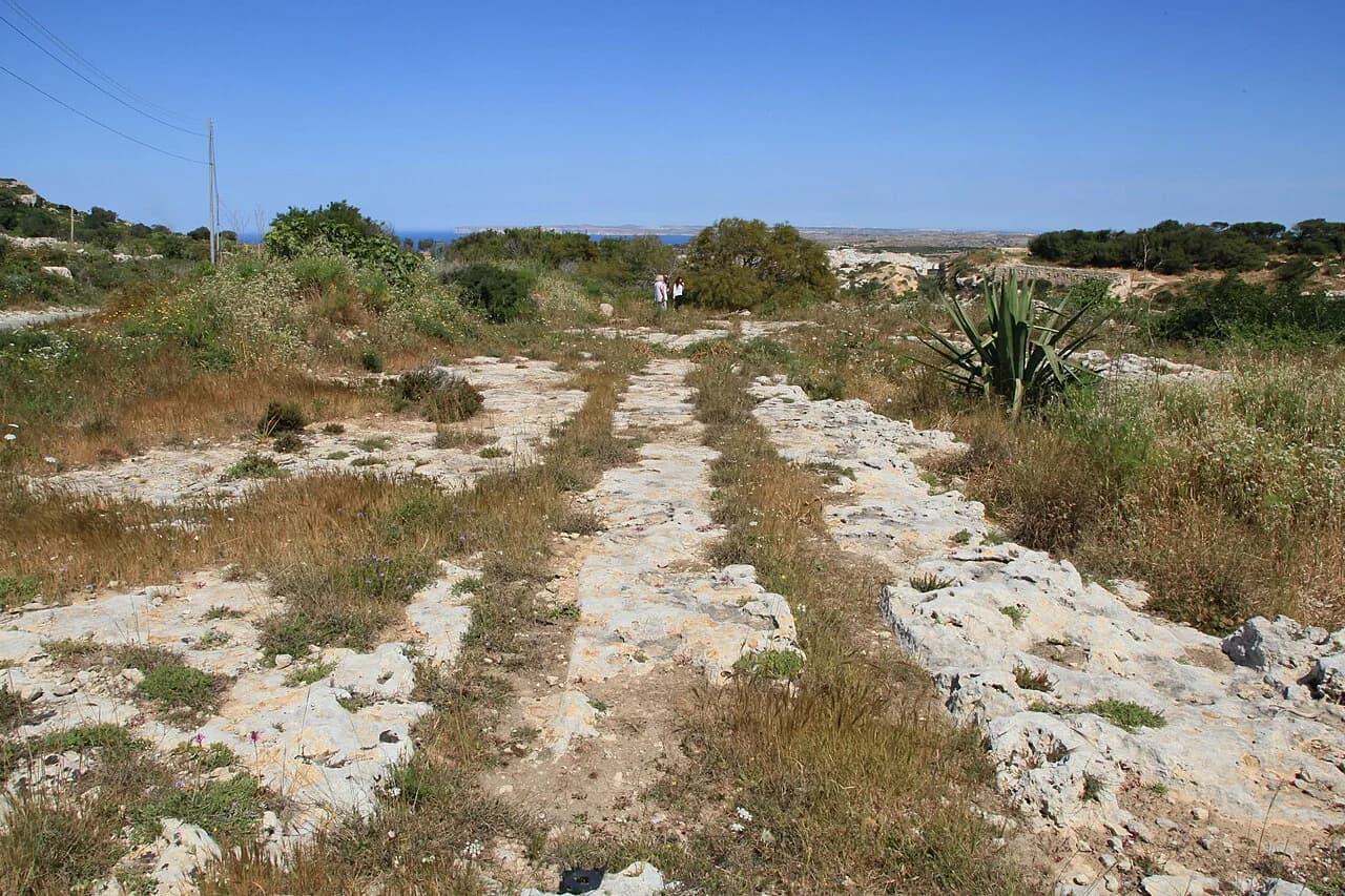
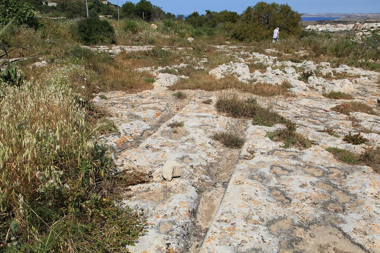
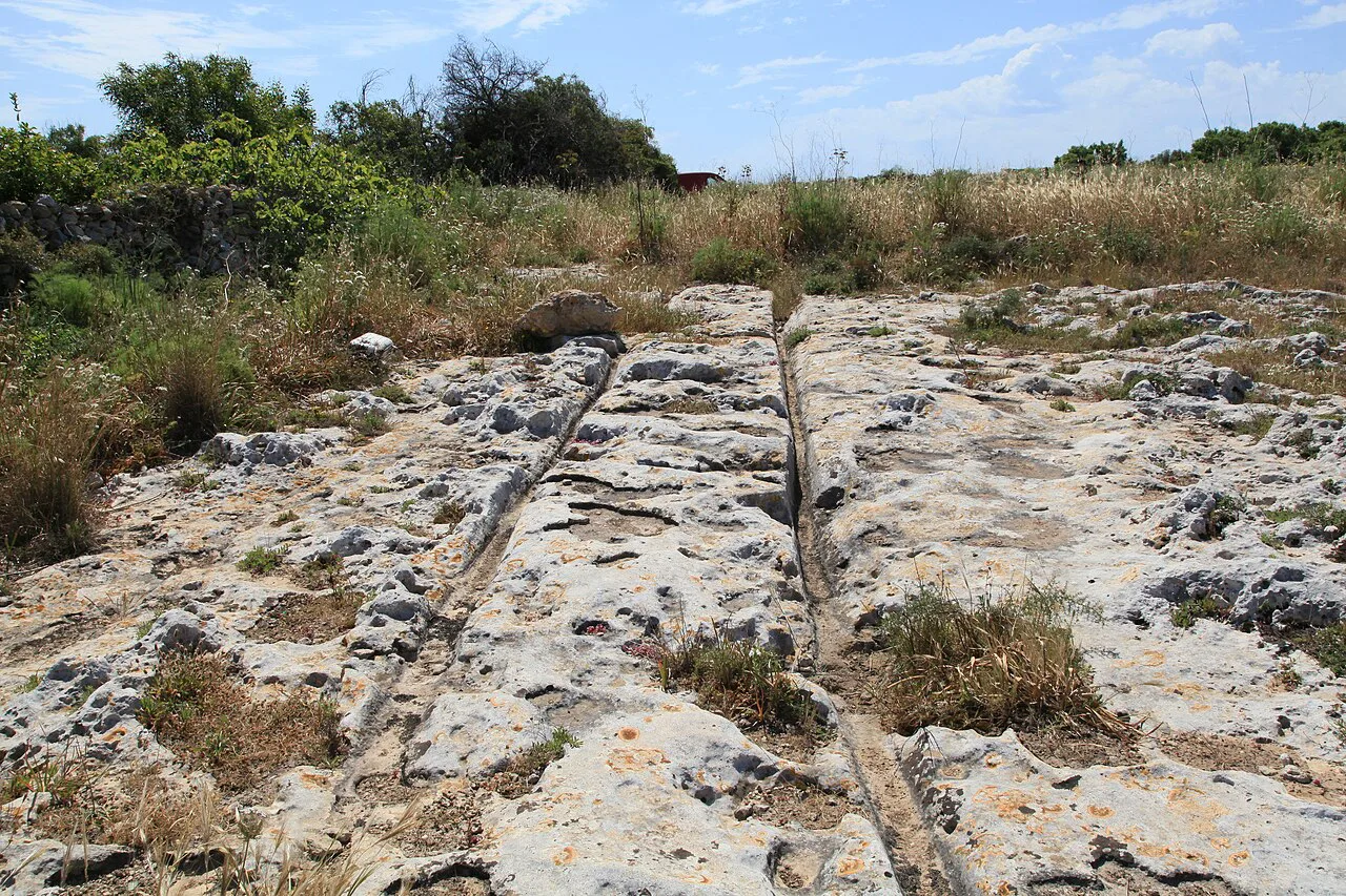
The ruts are grooves carved directly into the bedrock rather than tracks worn into soil. Some are U-shaped and some V-shaped, widths run between 10 and 50 centimetres, and the spacing between the two lines of a pair stays remarkably consistent at about 140 centimetres.
Lengths vary enormously: a pair may appear for a few metres and vanish, while others run for more than 100 metres and occasionally approach 300. Routes mostly run straight but also curve, and many stop abruptly at a cliff edge, at the sea, at quarries or close to ancient temples.
The first published description of the phenomenon in Malta dates from 1918, when E.G. Fenton wrote about the patterns in the journal Man. That century of study has produced plenty of measurement and no firm answer on origin.
Where the ruts are found
Ruts occur across Malta and Gozo in wildly different settings: hilly terrain, rocky plateaux, cliff edges and the shoreline. The main concentrations cluster around Rabat, Siġġiewi and Misraħ Għar il-Kbir, while further groups sit at Naxxar, Bidnija, San Ġwann and St Paul's Bay.
One well-known stretch lies beyond Naxxar on the flank of the steep downhill road called T'Alla u Ommu. New sets keep surfacing during road works, including ruts found near Mater Dei Hospital and others exposed at Attard on the road towards Rabat, so what is visible on the surface is not a fixed list.
The area around Misraħ Għar il-Kbir, known as Clapham Junction, is the most extensive local site, covering roughly 250,000 square metres. That scale is why this is the place to aim for if you want one visit that shows the phenomenon properly rather than a roadside glimpse.
Misraħ Għar il-Kbir, or Clapham Junction
The site takes its English nickname from the tangle of tracks at the London railway station, and the comparison holds: crossings, curves and dead ends lie over open rock rather than along a laid-out path. You walk the limestone plateau itself, so the layout is read from the ruts, not from signs or a marked trail.
Heritage Malta studied this plateau as the Maltese case in a European project on cart ruts in ancient landscapes, correlating it with a site at Padul in Spain. That research background is the reason Misraħ Għar il-Kbir is the site treated in most published discussion of the ruts.
The surrounding countryside near Buskett and Rabat is rural and exposed, with no shade over the plateau. The location sits within easy striking distance of Rabat's churches and the wider story of the islands, which you can follow up in this background to Malta history.
Ruts at Ta' Ċenċ, Dwejra and St George's Bay
Gozo has at least ten separate locations, among them the Ta' Ċenċ plateau above Sannat and the ground around Dwejra. At Dwejra, deep ruts approach the fortified tower and veer left to avoid it, which places the cutting of the ruts before the building of the tower.
The strangest set sits on the rocky shore in St George's Bay, just before Birżebbuġa. These ruts slide into the sea after several metres but once stretched about 50 metres along the rock to the left of the small sandy beach, and six pits roughly 40 metres to the right are thought to relate to the same tracks, possibly as grain silos.
That coastal position is the argument in miniature: ruts and silos both needed to sit well above the water line, so the sea must have risen since the grooves were cut. Read it as an observation about sea level rather than an explanation of the ruts themselves.
Timing, ground and daylight
Allow a half-day if you intend to walk a site properly rather than photograph one pair from a car park. The plateau at Misraħ Għar il-Kbir is open rock with no facilities, and the ruts can be subtle underfoot until you are close, so pace yourself and bring water.
These are public locations rather than ticketed monuments, and the published advice is not to walk them in the dark. Plan around daylight and avoid the midday heat in summer, when bare limestone reflects hard sunlight with no cover anywhere on site.
The ruts are formed in limestone, a rock that dissolves and weathers, which is part of why the grooves survive so clearly in some places and barely register in others. Check daylight hours and local conditions before setting out, since nothing is lit or staffed.
Getting to the main sites
Treat Rabat and Siġġiewi as your bases: both sit within a short drive of the main concentrations, and the Rabat side also puts Misraħ Għar il-Kbir and Buskett within one loop. A car makes short work of moving between clusters, which matters because the ruts spread over open countryside rather than one fenced site.
By bus, aim for Rabat or Siġġiewi and walk out from there; the Dingli Cliffs area near Siġġiewi holds tracks that are among the finest on the island. On Gozo, Ta' Ċenċ is reached from Sannat and Dwejra from the west coast road, so either makes a half-day of its own alongside other stops.
If walled towns and harbours interest you as much as prehistoric rock, the broader story of Malta's fortifications and defences places these rural sites usefully alongside the country's castles, bastions and stone-built towns. The same defensive instinct runs through the Knights Hospitaller's long building programme across the islands.
The theories: carts, sleds and dates
Nobody has reached a settled explanation. Scholars broadly agree the channels were deliberately dug to move bulky loads over difficult ground, probably with bronze or iron tools, but whether the loads were crops, soil for new fields or stone for rubble walls remains open.
The vehicles themselves are disputed. Many argue the carts had no wheels, because a wheel would jam in the V or U profile of the groove; others propose sleds with long poles trailing in the channels, dragged by mules, oxen or people. No cart, wheel or organic remains have been recovered from the ruts to settle it.
Dating is argued from what the ruts cut across and what they run into. Ruts crossing Punic graves must be older than the tombs, which supports a Late Bronze Age range of roughly 1800 to 700 BC, while others argue for Punic times from the 7th to 3rd century BC or even Roman dates after 218 BC.
Wider claims, including dates of five million years or an Ice Age origin tied to lower sea levels, are theories held by some rather than findings with scientific support. The same applies to ley-line and alien explanations, which carry no evidence.
Malta's ruts are not unique: similar grooves are recorded in Sicily, Sardinia, Spain, Italy, Greece and France, though Malta holds by far the highest concentration of the countries listed. That spread is a useful reminder that whatever produced them was not a one-off local accident.
What to pair with a cart-ruts visit
Several rut groups lead up to Bronze Age sites, which makes them a natural companion to the temple circuit. Examples include the ruts that run towards Borg in-Nadur, those at il-Qala Ta' San Martin and those near the Ġebel Ċiantar promontory not far from Dingli Cliffs.
About thirty sets of tracks end at or near ancient temples, so pairing a rut site with a temple visit follows the archaeology rather than padding the day. Build in time to read the information at the temple visitor centres, where the movement of stone blocks is discussed.
Nearby Rabat and Mdina reward a slower afternoon of churches after a morning on the rock; the island's church architecture is a different kind of stonework entirely, and this guide to Malta churches helps you pick which interiors are worth the stop.
Is the detour to the cart ruts worth it?
Yes, if you want to stand on open limestone and read a genuine puzzle rather than file past a labelled exhibit. Make Misraħ Għar il-Kbir your main stop from Rabat, add Dwejra or Ta' Ċenċ if you are on Gozo, and give St George's Bay a look on the way past Birżebbuġa for the ruts that walk into the sea.
Go in daylight, wear grippy shoes, carry water and expect no facilities or ticketing. Pair the visit with a temple or a walled town so the half-day carries more than one idea.
Explore more Malta guides
Sources
Notes for your Malta trip
Optional updates when we add or correct a Malta or Gozo guide.
You might also like
Continue reading
More guides you'll find useful